Table of Contents
ToggleIntroduction
Linear measurements form the cornerstone of surveying, serving as the fundamental basis for mapping, construction projects, and various engineering applications. The precision and accuracy of these measurements are critical, as they directly influence the quality and reliability of the final survey results.
Surveying, as a discipline, relies heavily on the ability to determine distances between points on the Earth’s surface with a high degree of accuracy. These measurements provide the raw data necessary for creating accurate maps, designing infrastructure, and planning construction projects. The importance of linear measurements in surveying cannot be overstated, as errors in these fundamental measurements can propagate throughout a project, potentially leading to significant issues in later stages.
There are two primary methods for determining distances between points on the Earth’s surface:
i. Direct Method
In this approach, distances are physically measured on the surface of the Earth using various instruments and techniques. This method involves the actual traversal of the distance being measured, typically using tools such as:
- Tapes (cloth, metallic, steel, or invar)
- Chains
- Electronic distance measuring (EDM) devices
- Wheeled instruments (odometers)
Direct methods are often preferred for their simplicity and immediacy, especially for shorter distances or in areas where line-of-sight may be obstructed.
1.Tapes
Tapes are essential tools in surveying, used for direct linear measurements. They are classified based on their material, each type offering different levels of accuracy, durability, and suitability for various surveying tasks. The four main types of tapes are:
a) Cloth or Linen Tape
Construction and Properties:
- Made of closely woven linen fibers
- Varnished or treated with a waterproof coating to resist moisture
- Typically 12 mm to 15 mm wide
- Available in lengths from 10 to 30 meters
- One end usually fitted with a metal ring
Uses:
- Primarily used for measuring offsets in chain surveying
- Suitable for rough measurements in preliminary surveys
Advantages:
- Lightweight and flexible
- Easy to handle and transport
- Relatively inexpensive
Limitations:
- Highly susceptible to moisture, leading to shrinkage
- Prone to stretching, especially when wet or under tension
- Can easily twist or tangle during use
- Markings may become indistinct with continuous use
- Not suitable for precise measurements or in windy conditions

b) Metallic Tape
Construction and Properties:
- Linen or synthetic tape reinforced with fine brass or copper wires
- Wires are interwoven into the fabric and not visible to the naked eye
- Available in various lengths, most commonly 20m and 30m
- Usually supplied in a leather case with a winding device
- Graduated in meters, decimeters, and centimeters
Uses:
- Offset measurements in chain surveying
- General surveying tasks requiring moderate accuracy
Advantages:
- More durable and accurate than cloth tapes
- Resistant to stretching due to metal reinforcement
- Less affected by moisture compared to cloth tapes
- Retains its length better over time
Limitations:
- Heavier than cloth tapes
- More expensive than cloth tapes
- Can kink or break if not handled carefully

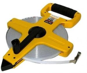
c) Steel Tape
Construction and Properties:
- Made of a thin strip of steel, typically 6 mm to 10 mm wide
- Available in various lengths: 10m, 20m, 30m, and 50m are common
- Highly accurate graduations
- Often includes a blank length at each end for protection
- Usually wound in a leather or metal case with a winding mechanism
Uses:
- Precise distance measurements in surveying
- Baseline measurements for triangulation
- Construction layout and engineering surveys
Advantages:
- High accuracy, superior to cloth and metallic tapes
- Maintains length well under normal use
- Resistant to stretching
- Can be calibrated for very precise measurements
Limitations:
- More expensive than cloth or metallic tapes
- Susceptible to temperature changes, requiring corrections for high-precision work
- Can rust if not properly maintained
- Fragile and can break or kink if mishandled
- Not suitable for use in areas with dense vegetation or rocky terrain

d) Invar Tape
Construction and Properties:
- Made of an alloy of 36% nickel and 64% steel
- Extremely low coefficient of thermal expansion (about 1/10th that of steel)
- Typically 6 mm wide and available in lengths of 30m, 50m, and 100m
- Often fitted with special tensioning devices for precise measurements
Uses:
- High-precision baseline measurements
- Geodetic surveys requiring utmost accuracy
- Calibration of other measuring devices
Advantages:
- Extremely high accuracy due to minimal thermal expansion
- Ideal for measurements requiring precision of 1:1,000,000 or better
- Essential for establishing primary control networks in large-scale surveys
Limitations:
- Very expensive compared to other types of tapes
- Requires careful handling to avoid deformation
- Softer than steel, making it more prone to physical damage
- Needs multiple assistants for proper handling and tensioning
- Requires frequent calibration as the alloy can develop creep over time
- Not suitable for routine surveying tasks
b) Chains
Chains have been a fundamental tool in surveying for centuries. Although largely replaced by more modern equipment in many applications, they still hold relevance in certain surveying tasks. Here’s a detailed look at the types of chains and their characteristics:
Types of Surveying Chains:
1.Gunter's Chain
- Length: 66 feet (20.1168 meters)
- Division: 100 links
- Link length: 0.66 feet (7.92 inches or 20.1168 cm)
- Historical significance: Basis for the old English area measure of ‘acre’
- Applications: Primarily used in land surveys in countries using imperial units

2.Engineer's Chain
- Length: 100 feet (30.48 meters)
- Division: 100 links
- Link length: 1 foot (30.48 cm)
- Applications: Commonly used in engineering surveys in countries using imperial units
3.Metric Chain
- Length: Typically 20 meters or 30 meters
- Division: 100 links (for 20m chain) or 150 links (for 30m chain)
- Link length: 0.2 meters (20 cm)
- Applications: Standard for most modern surveying work in countries using the metric system
Features of a Metric Chain:
- Construction:
- Made of galvanized mild steel wire, typically 4 mm in diameter
- Links are connected by oval-shaped rings (usually three) for flexibility
- Total of 100 or 150 links, depending on the chain length
- Handles:
- Brass handles with swivel joints at each end
- The outside of the handle marks the zero point or end point of the chain
- Handles often have grooves to hold arrows in the correct position
- Tallies and Tags:
- Metallic tags of different shapes attached at key points:
- Circular tag at every 5 meters
- X-shaped tag at 10 meters (middle of a 20m chain)
- Rectangular tags at 15 meters and 25 meters (for 30m chain)
- These tags allow for quick and easy reading of chain lengths
- Metallic tags of different shapes attached at key points:
- Link Design:
- Each link consists of a piece of wire with loops at both ends
- The length of a link is measured from the center of one middle ring to the center of the next
- Markings:
- Handles are marked with ‘M’ to indicate metric measurement
- The total length of the chain (20m or 30m) is usually stamped on the handle
- Construction:
c) Electronic Distance Measuring (EDM) Devices:

EDM devices have revolutionized surveying by providing rapid, accurate measurements over long distances. These instruments use electromagnetic waves to determine distances.
Key features of EDM devices:
1.Operating Principle:
- Emit electromagnetic waves (infrared, laser, or microwave)
- Measure the time or phase difference of the returned signal
- Calculate distance based on the speed of light
- Types:
- Total Stations: Combine EDM with electronic theodolites
- Handheld Laser Distance Meters: Portable devices for shorter ranges
- GPS/GNSS Receivers: Use satellite signals for positioning and distance measurement
- Accuracy:
- Can measure distances up to several kilometers with millimeter-level precision
- Accuracy typically ranges from ±(2mm + 2ppm) to ±(5mm + 5ppm)
- Range:
- Varies by device type and environmental conditions
- Can measure from a few meters to several kilometers
- Advantages:
- High accuracy and precision
- Rapid measurements
- Can measure long distances without direct access
- Often integrate with data collection and processing systems
- Limitations:
- Require clear line of sight (except for GPS/GNSS)
- Can be affected by atmospheric conditions
- More expensive than traditional tools
- Require power source and occasional calibration
- Applications:
- Topographic surveys
- Construction layout
- Monitoring structural deformation
- Boundary surveys
d) Wheeled Instruments (Odometers):
Odometers are wheeled instruments used for measuring distances along the ground. In surveying, they provide a quick method for rough distance measurements, especially useful in preliminary surveys or for measuring long distances where high precision is not required.

Key features of surveying odometers:
- Design:
- Consist of a wheel of known circumference
- Attached to a handle or frame for easy rolling
- Include a counter mechanism to record revolutions
- Types:
- Mechanical Odometers: Use gears to count wheel rotations
- Digital Odometers: Employ electronic sensors for more precise counting
- Operation Principle:
- The wheel is rolled along the path to be measured
- Each revolution corresponds to a known distance (the wheel’s circumference)
- The counter records the number of revolutions
- Distance = Number of revolutions × Wheel circumference
- Accuracy:
- Typically accurate to within 0.1% to 1% of the measured distance
- Accuracy depends on terrain conditions and wheel maintenance
- Advantages:
- Quick and easy to use
- Suitable for long distances on relatively flat terrain
- No need for line-of-sight between points
- Can measure curved paths easily
- Limitations:
- Less accurate on uneven or soft surfaces
- May overestimate distances on hilly terrain
- Not suitable for high-precision measurements
- Wheel size can change slightly with wear, affecting accuracy
- Applications:
- Preliminary surveys and route planning
- Road and railway surveys
- Rough estimation of distances in urban planning
- Measuring distances along curved paths
- Variants:
- Trundle Wheels: Larger wheels for outdoor use
- Measuring Wheels: Smaller, more precise wheels for indoor measurements
- Maintenance:
- Regular checking of wheel circumference
- Ensuring the wheel runs true without wobble
- Keeping the counter mechanism clean and functional
ii. Computative Method (Indirect Method)
This method involves determining distances through mathematical calculations based on other measured quantities. Examples include:
- Tacheometry: Using optical principles to calculate distances based on vertical angles and stadia readings
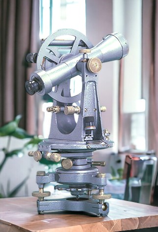
- Triangulation: Employing trigonometric principles to compute distances within a network of triangles
- Trilateration: Using the known positions of three or more points to determine the location of another point
Indirect methods are particularly useful for measuring long distances, spanning difficult terrain, or when direct access to the points being measured is impractical.
The choice between direct and Indirect methods depends on various factors, including the required accuracy, the nature of the terrain, the available equipment, and the specific requirements of the survey project.
As surveying technology has advanced, the line between direct and Indirect methods has blurred somewhat. Modern electronic distance measurement (EDM) devices, for instance, use principles of both direct measurement (by sending out electromagnetic signals) and computation (by calculating distances based on the time taken for signals to return).