Table of Contents
ToggleContours are an essential element in topographic mapping, providing a visual representation of the Earth’s three-dimensional surface on a two-dimensional plane. Understanding the characteristics of contours is crucial for accurately interpreting and creating topographic maps. Let’s explore these characteristics in detail:
1. Contours of Different Elevations Do Not Intersect
Contour lines representing different elevations never cross each other, except in the rare case of an overhanging cliff where the land surface folds over itself.
This principle is fundamental to topographic mapping, ensuring a consistent and accurate representation of terrain elevation. It reflects the physical reality that a single point on Earth’s surface cannot exist at two different elevations simultaneously. The non-intersection rule allows for clear visualization of elevation changes across the landscape, making it easier for map readers to interpret the three-dimensional terrain from a two-dimensional map. In digital mapping and GIS, this principle is crucial for accurate 3D terrain modeling. The exception of overhanging cliffs is typically represented using special cartographic techniques, such as dashed lines or supplementary cross-sectional views. Understanding this characteristic is essential for identifying potential mapping errors and recognizing areas of complex topography that may require closer examination.

2. Contours Do Not Merge
Contours with different elevations do not combine into a single line, except when representing a vertical cliff, where the slope changes abruptly.
This principle is crucial for preserving the accuracy and readability of topographic maps. By keeping contours separate, the map clearly represents gradual changes in elevation across the terrain. The exception of vertical cliffs highlights extreme topographic features where elevation changes abruptly. This separation allows map users to trace individual contours, enabling precise elevation readings at any point. It also facilitates the identification of landforms such as hills, valleys, and plateaus. In digital mapping, this characteristic is essential for creating accurate 3D models and conducting spatial analyses. Understanding elevation separation helps in interpreting complex terrains and identifying potential hazards in activities like hiking or construction planning.

3. Spacing of Contours Indicates Slope
The closeness of contour lines reveals the steepness of the terrain. When contour lines are closely spaced, they indicate a steep slope. Conversely, widely spaced contours represent a gentle slope.
Understanding this relationship is vital for various applications, from route planning for hikers to site selection for construction projects. It also aids in identifying potential hazard zones, such as areas prone to landslides or rapid water runoff. Map users can quickly discern the relative difficulty of traversing different parts of the landscape, making this feature particularly valuable for land managers.
4. Equidistant Contours Represent Uniform Slopes
Equally spaced contours indicate a uniform slope, providing valuable information about terrain consistency. When contours are parallel, equidistant, and straight, they represent an inclined plane surface. This characteristic allows map readers to quickly identify areas with consistent gradients. Such uniform slopes are significant in various applications, including agriculture, urban planning. For instance, they may indicate ideal locations for crop cultivation or potential sites for roads or buildings. The regularity in spacing also helps in calculating slope angles and predicting water flow patterns. In natural landscapes, uniform slopes are less common, making their presence noteworthy. Understanding this feature enables more accurate terrain analysis and aids in decision-making processes for land use and development projects. It’s particularly useful in identifying stable areas for construction or assessing erosion risks in agricultural settings.
5. Contours and Slope Direction (Perpendicularity to Steepest Slope)
At any given point, a contour line is always perpendicular to the steepest slope. This relationship helps in identifying the direction of maximum slope in the terrain.
Understanding this relationship helps in determining the direction of water flow, as water naturally follows the path of steepest descent. This knowledge is invaluable for predicting potential erosion patterns and drainage systems. In hydrology and civil engineering, this principle aids in designing effective water management structures and erosion control measures. For hikers and outdoor enthusiasts, it assists in route planning by indicating the most challenging uphill or downhill paths. In agriculture, this property helps in planning irrigation systems and terracing. The perpendicularity rule also enables accurate slope calculations, which are essential for various land use and development decisions.
6. Contours Form Closed Loops
Every contour line eventually closes on itself, either within or beyond the map’s boundaries. This principle means that contours never just end—they must always form a loop, though it may not always be visible within the map’s limits.
It reflects the natural continuity of terrain features, where elevations don’t abruptly start or end. Understanding this concept helps map readers visualize the broader landscape context, even when limited by the map’s edge. For cartographers, it guides the accurate extension of contours to map edges. This characteristic is crucial in digital mapping and GIS, ensuring seamless integration of adjacent map sheets. It also aids in interpreting partial landforms at map boundaries, allowing users to infer the complete shape. The closure principle reinforces the three-dimensional nature of the terrain being represented on a two-dimensional surface, enhancing overall map comprehension and utility.
7. Ring Contours Indicate Hills or Depressions
A series of concentric contours, with higher elevations towards the center, represents a hill. Conversely, when the inner contours have lower elevations, it indicates a depression or a basin, such as a pond, provided it lacks an outlet.
These patterns enable rapid visual interpretation of terrain features without relying solely on elevation numbers. Understanding these configurations is crucial for various applications, including land-use planning, geological surveys, and outdoor recreation.

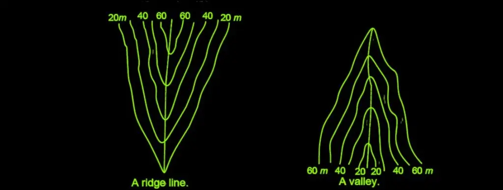
8. Contours in Valleys and Ridges
When contour lines cross a valley or a ridge, they form distinct “V” shapes. In the case of a ridge, the “V” points towards lower elevations. For valleys, the “V” points uphill, towards higher elevations.
9. Consistency Across Features
The same contour line must appear on both sides of a ridge or valley, ensuring consistency across the terrain feature.
Imagine a valley between two hills. If a contour line at 100 meters elevation appears on the left slope of the valley, it must also appear on the right slope at the same elevation. This ensures that both sides of the valley are represented consistently and that the terrain’s topography is accurate.
10. Contours Show Smooth Curves
In most cases, contour lines follow smooth, gradual curves that reflect the natural landscape. Sharp turns in contour lines are rare, as they would indicate highly irregular terrain.
This characteristic reflects the natural, gradual transitions in terrain elevation. Sharp angles in contour lines are rare and usually indicate unusual geological features or human-made structures.
Additional Considerations:
- Contour Interval: The vertical distance between adjacent contours, known as the contour interval, is consistent throughout a map. This interval is chosen based on the map’s scale and the terrain’s complexity.
- Index Contours: Every fifth contour is typically emphasized and labeled with its elevation, serving as an index contour. This aids in quick elevation determination and improves map readability.
- Supplementary Contours: In areas of minimal relief, cartographers may employ supplementary contours at half the standard interval to provide additional topographic detail.
- Interpolation: Skilled map readers can estimate elevations between contours through interpolation, enhancing the map’s utility for precise elevation determinations.
- Contours Avoid Permanent Structures: Contour lines do not pass through permanent structures like buildings, bridges, or other man-made constructions