Table of Contents
TogglePrinciples of Triangulation
The underlying principle of triangulation is based on trigonometry. If the angles of a triangle and the length of one of its sides are known, the lengths of the remaining sides can be calculated using basic trigonometric functions. Additionally, if the coordinates of one vertex and the azimuth (the angle between a reference direction and a point) of one side of the triangle are known, the coordinates of the other vertices can be computed as well.
In triangulation, the known side of the first triangle is referred to as the baseline. The points or stations at the vertices of the triangles are known as triangulation stations. To minimize errors, additional baselines, called subsidiary bases, are established at suitable intervals. These subsidiary bases serve to control the accumulation of errors in the lengths of the sides of the triangles.
To maintain accuracy in the azimuths (the angular measurements), astronomical observations are made at certain triangulation stations. These stations, where such observations are conducted, are referred to as Laplace stations. The astronomical observations help correct any errors that may arise from instrument imperfections, local deviations in the Earth’s magnetic field, or atmospheric conditions that could affect angular measurements.
Historical Development of Triangulation
The method of triangulation was first introduced by the Dutch mathematician and surveyor Willebrord Snell in 1615. Snell’s work laid the foundation for modern geodetic surveying, allowing for more accurate and efficient mapping of large areas. His principles of using trigonometry to calculate distances based on angular measurements revolutionized the field of surveying and led to the development of the triangulation techniques still in use today.
Over time, triangulation evolved and became more refined with advancements in instruments and computational methods. Today, triangulation remains a fundamental technique in geodesy, the science of measuring the Earth’s shape, and continues to play an integral role in topographical surveys, engineering projects, and national mapping efforts.
Purpose of Triangulation Surveys
Triangulation surveys are a key method in surveying, where a network of triangles is used to measure distances and angles with high precision. These surveys play a fundamental role in establishing accurate control networks, which serve as the backbone for both large-scale mapping and engineering projects. The main purposes include:
Establishing Control Points for Large Surveys
Triangulation surveys help in setting up highly accurate control points for both plane and geodetic surveys across vast areas using ground-based techniques. These control points are essential for ensuring the accuracy of the overall survey.Providing Control for Photogrammetric Surveys
In photogrammetry, where aerial photographs are used to map extensive regions, triangulation surveys provide critical ground-based control points to ensure precision in the resulting maps.Accurate Location of Engineering Works
These surveys are crucial in determining precise locations for large-scale engineering works, including:- Fixing the centerline, terminal points, and shaft alignment for long tunnels.
- Positioning the centerline and abutments of bridges spanning large rivers or other obstacles.
- Transferring control points across wide sea channels or significant water bodies to maintain alignment and accuracy.
- Observing and recording the direction of cloud movement to assist in weather studies and other atmospheric research.
The Role of Modern Technology
While traditional ground methods remain vital, modern technologies like GPS and satellite-based systems have greatly enhanced the accuracy and efficiency of triangulation surveys, making it possible to achieve precision over even larger areas.
Ideal Figures for Triangulation
When selecting the ideal geometrical figure for a triangulation system, several key factors should be considered to ensure maximum accuracy and stability in the survey. These considerations are as follows:
Simple Triangles
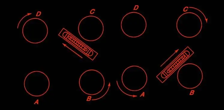
Ideally, simple triangles should be equilateral, as this shape provides optimal balance and reduces potential errors during measurements.Braced Quadrilaterals
A braced quadrilateral, a figure with diagonals observed for additional strength and accuracy, should preferably form a square. This ensures symmetry and simplifies calculations.Centered Polygons
In triangulation systems involving polygons, centered polygons should be regular, meaning all sides and angles should be equal. This regularity helps in maintaining uniformity across the triangulation network.Avoid Small Angles Opposite Known Sides
In any figure, the angle opposite a known side should not be small, regardless of which end is used for computation. Small angles can introduce significant errors during calculations.Minimum Angle Requirements
- In simple triangles, no angle should be less than 45°.
- For quadrilaterals, the minimum angle should not be less than 30°.
- In the case of centered polygons, no angle should be less than 40°.
Comparable Side Lengths
The sides of the chosen figure should be of comparable lengths to maintain the accuracy and reliability of the triangulation network.
If a triangle includes a very small angle that is not opposite a known side, it does not significantly affect the accuracy of the triangulation. In such cases, neither the length of the sides nor the azimuths will be compromised.
Layout of Primary Triangulation for Large Countries
For large countries, the framework of primary triangulation can be established using two common systems:
(a) Grid Iron System
(b) Centered System
1. Grid Iron System
In this system, the primary triangulation consists of a series of chains of triangles that run roughly along the country’s meridians (north-south) and perpendiculars to these meridians (east-west). These chains create a grid-like pattern that covers the entire region. The distance between two adjacent chains typically ranges from 150 to 250 kilometers.
The spaces between these primary chains are further subdivided using secondary and tertiary triangulation systems. This approach ensures that the entire area is accurately mapped. The Grid Iron system has been widely adopted in countries such as India, Austria, Spain, and France

2. Centered System
In the Centered system, the entire area is covered by a network of primary triangulation that radiates outward from a central baseline, which is usually positioned at the center of the country. This baseline serves as the starting point for triangulation and extends in all directions, creating a network that spans the country. This method is particularly suited for surveying regions of moderate size and has been used in countries like the United Kingdom.